Margam Mountain
001 Margam Abbey and Castle
HLCA 001 Margam Abbey and Castle
Significant early medieval/medieval ecclesiastic and monastic centre with church and cemetery; important early medieval ecclesiastic/secular settlement and administrative focus; important and influential post-medieval gentry estate and deer park; registered parkland and gardens; post-medieval vernacular and other notable buildings; important relict multi-period/multi-functional archaeological landscape; buried archaeology includes cropmarks and find scatters; Ancient and other broadleafed woodland and plantation; important historic associations. Back to Map
Historic Background
This outstanding landscape, sheltered by wooded slopes to the east and located between the hills and the sea on the course of the former Roman communication route to West Wales, was an area of substantial religious importance during the early medieval period and subsequently during the medieval period when the great Cistercian Abbey of Margam was constructed.
The area is largely coterminous with the Margam Country Park, and is included on the Register of Parks and Gardens in Wales (Cadw Ref number PGW (Gm) 52 (NEP), where it is evaluated as being of grade I status (Cadw; ICOMOS UK, 2000, Glamorgan: Register of Landscapes, Parks and Gardens of Special Historic Interest in Wales. Part 1 Parks & Gardens). Of particular importance within the area is the very fine walled deer park, the banqueting house façade, the outstanding Georgian Orangery and Citrus House and 19th century gardens with their fine collection of trees and shrubs, associated with famous plant hunters of the Victorian age such as Frank Kingdon Ward. The 1950s garden of Twyn-yr-hydd is a delightful and well-preserved period piece within the park (Cadw; ICOMOS UK, 2000).
The park can be divided into three main areas, two of which are within the current HLCA: the first is the low-lying ground to the south, bounded on the west by the main grounds and gardens and on the north by the steep ridge of Craig-y-Lodge; secondly, the wooded valley, lake and hillfort at the west end of the park; and finally outside the current HLCA, the northern part of the park (HLCA 015 Upper Park and Ton-y-grugos), situated on a high, rolling plateau above the ridge, and bounded by the valley of Cwm Philip to its north-west. Each part differs slightly in character and use. Halls estate map of 1814 shows these three varying areas and gives them Little Park, Great Park and Upper Park (HLCA 015), respectively.
The historic landscape area of Margam Abbey and Castle contains a nationally important and impressive collection of architecture and sculpture unparalleled elsewhere in Wales and spanning an entire millennium, from the 9th to the 19th centuries. The long-standing strategic and administrative importance, based on its prime location at the boundary between the uplands and the sea is demonstrated by the remains of all periods from the late prehistoric to the post-medieval. The importance of the area as an early medieval ecclesiastic focus is also evident from Early Christian Monuments (inscribed and decorated stones) found in the vicinity of the Cistercian Abbey (including the Conobelin, Pumpeius, Ilqui, Bodvoc and Grutne stones, among others). The earlier existence of a polygonal or circular churchyard enclosure around the Abbey church at Margam is depicted in Hills Estate Survey of 1814, an additional indication of the whereabouts of the early medieval church site. A further early medieval ecclesiastic site has also been tentatively identified at Cryke, Capel Mair (PRN 0765w; Hen Eglwys) based on churchyard morphology, with evidence of a circular or polygonal enclosure/church yard (Evans 2003). A find of imported Frankish glass indicates the site was open to wider patterns of exchange and trade during the early medieval period (cf Hen Gastell, Wilkinson 1995). The hillfort of Mynydd-y-castell (SAM Gm 162), in terms of morphology and location, is at variance with most of the other defended enclosures (see sections 6.4 - 6.5) within the historic landscape, being of a massively defended promontory or summit type (similar to but on a larger scale than the site at Hen Gastell), with a possible internal dwelling platform. While Mynydd-y-castell is considered to be of late prehistoric date (RCAHMW), the site may well prove to be a high status secular settlement and administrative focus for the region during the early medieval period (see section 6.4).
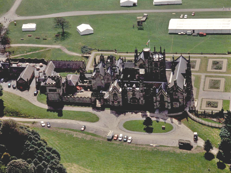
In 1147 the lands at Margam were granted by Robert of Gloucester, lord of Glamorgan, to St Bernards abbey of Clairvaux, for foundation of a new Cistercian house of Margam. The nave of the 12th century church survives, in use as the parish church. At the start of the 13th century the Abbey was re-constructed by Abbot Gilbert (1203-13) and the chapter house (standing but lacking its vault, which fell in 1799) and the eastern part of the church, presbytery, choir and transepts date from this time. Following the dissolution in 1536, Sir Rice Mansel of Oxwich and Old Beaupre acquired most of the ex-monastic estates. By the late 16th century a faire and sumptuous house had been erected, incorporating some of the monastic buildings, and stables added during the late 17th century.
Under Thomas Mansel Talbot the mansion at Margam was abandoned in favour of Penrice Castle on Gower and developed as a pleasure garden, finalised by 1814, and dominated by an imposing Orangery in the Palladian style the largest in Britain, built 1787 - 90 to designs by Anthony Keck. The present internal layout of the park is largely the work of C R M Talbot, who transformed it from 1828 onwards, after returning the family seat to Margam. He was also responsible for the construction of the new Tudor-style house (1830-5 by Thomas Hopper; site architect - Edward Haycock). The irregular plan and pinnacled, and castellated skyline of the house give it a Romantic appearance. It is built of local Pyle ashlar stone, arranged around three courtyards, one in the centre of the main block and two former service courts to the east. There are two main storeys, with a gabled third storey. The surfaces of the building are ornamented with carvings and sculpted heraldic panels. A dramatic two-storeyed octagonal tower with attached stair turret and surmounted by a viewing room is located at the centre of the building. The house is aligned east-west with its main entrance front on the north. Another interesting structure erected during the period is the temple of the four seasons, which incorporates the façade of the late 17th century Summer Banqueting House, re-erected in 1835.
The park contains a number of other typical estate buildings of the 1840s in Tudor style, also attributed to Haycock such as the west lodge near the church (gabled, tall chimneystacks).
The former village of Margam, a post-medieval foundation indicated on an estate map of 1813 and depicted on the Delamotte painting of Margam (NMW; early 19th century), was located near the surviving almhouses, a linear development leading from the Abbey gateway. This settlement appears to have been cleared away during the 1830s and 40s, its site incorporated into the kitchen gardens, and the inhabitants rehoused at a new settlement at Groes (RCAHMW Glamorgan, Adams, D J, 1986).
Historic Landscape Characteristics
Margam Abbey and Castle, an extensive valuable recreational/open space and tourism resource, lies partly within a Conservation Area, and is approximately coterminous with Margam Park registered garden; the park, roughly triangular and mostly bounded by a substantial rubble stonewall, is of varying character and situated between the ridge of Mynydd Margam, to the north and north-east, and the coastal plain to the west.
The area is characterised as a multi-period landscape of outstanding historical importance and includes significant remains from the prehistoric, early medieval, medieval and post-medieval periods, and has Tudor, eighteenth-century and nineteenth-century gardens and landscapes. The area formed a significant ecclesiastic/monastic estate with imposing medieval Cistercian Abbey church and cemetery, later converted to an important and influential post-medieval gentry estate and deer and Landscape Park with pleasure grounds, gardens and former kitchen garden. The area has important examples of medieval ecclesiastic and post-medieval secular and vernacular architecture, many listed and some scheduled.
The area is an important relict archaeological landscape including pre-historic, medieval and post-medieval settlement/fields and pre-historic defensive features, such as Mynydd-y-Castell hillfort (SAM Gm 162), a dominant landscape feature in its self. The relict features are complimented by buried archaeology, which is evidenced by cropmarks and find scatters. The area contains a considerable wealth of medieval and post-medieval buildings and structures, most of which are listed, these are as follows: Margam Castle (grade II*); Orangery (grade I); Chapter House Ruins (grade 1); Infirmary Ruins (grade I); the Abbey church of St Marys (grade A); the churchyard walls and gate piers (grade II); Almshouses (grade II); Temple of the Four Seasons (grade II); the remains of the monastic mill (grade II); Kitchen garden walls (grade II); Terrace walls and screen grade II); Middle Lodge (West Lodge) (grade II); Gate piers and screen at East Lodge (grade II); Margam Park wall and gate piers along A48 (grade II); Ruins of Hen Eglwys (grade II). The scheduled ancient monuments of the area are Hen Eglwys (Gm 163); Margam inscribed and sculptured stones (Gm 21); Margam Abbey (Gm 5).
Other characteristics include Ancient and other broadleafed woodland and 19th century plantation, important historic associations from the medieval and post-medieval period, and minor communication features such as the course of former old parish road between Taibach and Llangynwyd, diverted in 1829 to avoid crossing the park.