Gower
048 Oxwich
HLCA048 Oxwich
Medieval and post-medieval agricultural landscape and former manorial centre: varied settlement pattern (shrunken medieval settlements); post-medieval vernacular buildings; varied fieldscape; traditional boundaries; relict multi-period defensive structures; unimproved cliff edge; woodland; and rural industry. Back to Map
Historic Background
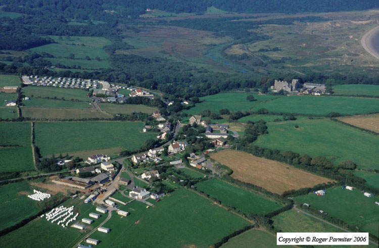
The historic landscape area of Oxwich represents the approximate extent of the former Knight's fief of Oxwich minus the coastal marsh and dunes to the northwest. The area encompasses the settlements of Oxwich, and Oxwich Green, together with associated field systems, and outlying farmsteads. There is a small area of semi-natural ancient woodland located on the northeast-facing slope between Norton and Oxwich Castle. Apart from the coastal and woodland areas to the south and northeast, the area borders Penrice to the north and Horton to the west. The settlements of Oxwich and Oxwich Green are both designated as conservation areas (EV 9) in the Swansea Unitary Development Plan.
Numerous caves are known to exist along the coastal margins, the limestone escarpment at Slade Cliffs and Oxwich Point, including Thornbush, Ramson's Hole and Oxwich Point caves; none have so far produced evidence of prehistoric occupation. Little archaeological evidence is recorded for the area earlier than the medieval period other than a promontory fort known as Maiden Castle (00297w; 301333) may relate to occupation during the prehistoric period or early medieval periods, but this needs further confirmation. The site, considered to be domestic, comprises an oval ring ditch c.5m wide, and encloses an area of 0.2 ha on ground rising very gently towards the Southwest and falling away more steeply on other sides. A number of stray finds of the prehistoric period have also been recovered.
During the medieval period the settlement of Oxwich formed the core of the fief of Oxwich and was held jointly with Port Eynon by the Delamare family in Gower Anglicana (Nicholl 1936, 169). A charter of c.1230 confirms a gift of 10 acres of land in the fief of Oxwich by Robert Delamare to the Knights' Hospitallers, which probably refers to an original grant of the late twelfth century. The ringwork at Norton (00166w; 93092; SAM GM157), near Oxwich may have been part of the holdings of the Delamare family; unfortunately little is known of the history of the Norton site, a partial ringwork with an internal house-platform. Oxwich is considered to be one of the twelve 'ancient knights' fees' held by military service before 1135, which are listed in a charter of 1306. During the first half of the thirteenth century both Oxwich and Port Eynon passed to the Penres family of Penrice and likewise in the late 14th /early 15th century passed to the Mansel family, along with Penrice, and by the eighteenth century the Mansel Talbot family. (RCAHMW 1991, 28-30, 120-121; Nicholl 1936,168-169; Draisey 2002, 14, 59, 69 and 81).
The church of St Illtyd (00299w; 303016; LB 11536 II*) with its sub-circular churchyard and pre-Norman dedication, probably originated during the early medieval period. Its coastal location away from any settlement nucleus may indicate origins as an early medieval monastic cell. The nave and chancel of the current structure with its Norman arch is considered to be of twelfth century date though the unusual smallness of the chancel raises the possibility of an earlier structure is incorporated. The nave is evidently of two builds, with a marked change in width at the centre, which is only apparent externally, the east part of the nave walls being much thicker than the west part. The nave may have been extended to the west at the time the tower was added, possibly during the fourteenth century. The building contains interesting fourteenth century memorials including a tomb inserted in the chancel, possibly of a member of the de la Mare or Penrice families. The church underwent considerable restoration during the nineteenth century (Newman 1995, 481; Orrin 1979, 53-56).
Oxwich Castle (00187w; 19994; SAM GM043; LB 11530 I) may retain fragments of an earlier medieval structure, incorporated into the later northeastern range, other indicators of an earlier origin may be found in the vestiges of a tower 150m to the northeast (SAM GM472). The main remains are essentially of the Tudor period, considered as an Elizabethan prodigy house of national importance. The castle was in the ownership of the de la Mere family until the thirteenth century. It came to the Penrice family and thence before 1459 to the Mansel family who rebuilt it. The Mansels have been described as belonging to a 'powerful gentry class whose lifestyle resembled that of past feudal magnates'.
The castle was described by Merrick in 1578 as 'lately re-edified or repaired by Sr. Ed: Mansell, kt.' and the same writer identifies Sir Rice Mansel as builder of the earlier part. The interpretation placed on this by the Royal Commission was that the southeastern range was built by Sir Rice Mansel in the 1520s or 1530s, and the northeastern range (with great hall and long gallery, plus a tower to the east) was added by his son Sir Edward Mansel in the 1560s or 1570s. This has, however, been challenged, on the basis of structural evidence. The castle ceased to be occupied by the Mansel family in c.1630 and the northeastern range and east tower then fell into disrepair. The southeastern range continued to be used as a farmhouse. Structural evidence also suggests the southeastern range was formerly one storey higher than it is now. The castle is now in the care of Cadw. The southeastern range is roofed and a modern staircase and custodian's office have been inserted. The other parts are consolidated ruins (Davies 1997, 55-56; Newman 1995, 481-3; RCAHMW 1981, 63-76; Williams 1998).
At Oxwich Green, the now unfortunately destroyed late sixteenth century Oxwich Green Farm House (00284w) was of considerable importance, a two-unit direct-entry house with lateral chimney to both hall and parlour, originally comprised an open hall with a storeyed parlour and was of a plan more easily paralleled in Pembrokeshire or North Devon (RCAHMW 1988, 731). Many of these farms around Oxwich Green such as the farmstead of Western Slade (02182w), referenced in the seventeenth century Cromwellian survey of Gower, probably dated to the early post-medieval period.
The first edition 25-inch OS, 1879, shows the main settlement of Oxwich as a dispersed ribbon of less than half a dozen cottages, extending northwest from the rectory and the linear finger of land at the base of Oxwich Wood, containing the Church, towards and beyond the Primative Methodist Chapel, with Norton farm and the site of the ringwork overlooking the area. The fieldscape and settlement is essentially the same as depicted on the late eighteenth century estate map, apart from minor amalgamation of some smaller enclosures. The settlement at Oxwich Green to the west appears as the main agricultural settlement of the area, comprising a cluster of farmsteads around a village green with lanes accessing the surrounding farmland, generally as shown on the eighteenth century estate plan of the area, with additions of cottages and a Wesleyan Methodist Chapel built in 1871, and a quadrangle of farm buildings immediately north of the substantial Oxwich Green Farmstead, all constructed on the roadside or within the margins of the Green. Other nineteenth century additions include a smithy at the northeast edge of the settlement. The farmsteads of the area, well developed by the late eighteenth century, are all located adjacent to routes probably established by the medieval period. The estate plan of 1783 indicates that the outlying farmsteads of Ganderstreet, Herronstreet, Eastern Slade, and possibly Sladecross, may well have developed from small medieval agricultural settlements or hamlets, with some minor dwellings disappearing during the nineteenth century to be replaced by purpose built agricultural ranges. The farmstead and buildings at Norton depicted on the late nineteenth century 1st edition 25-inch OS map appear to be those indicated on the 1783 estate plan; the possibility remains that many of these buildings could survive to the present in some form.
By the nineteenth century Oxwich Castle gains a linear range of farm buildings to the south, and a new road has been added leading from the coastguard station at Oxwich, passed Oxwich Castle, to join, just east of Ganderstreet Farm, with the ancient sunken lane between Oxwich and Oxwich Green. A comparison between the eighteenth century estate plan, the 1st edition OS map and current maps would indicate that the vast majority of the area's farmsteads and cottages survive, and that little has changed in plan since the eighteenth century. The possibility of interesting architectural survivals cannot be ruled out.
The development of the linear settlement of Oxwich has been previously described (Nuttgens 1979, 5-16). The settlement is dominated by small 'landless' cottages of eighteenth century date, and is likely to be a relatively late development in the area; it lies on marginal land adjacent to the dunes and marsh, below and away from what would have been the best land and the location of the former open fields of the area. A better candidate for the earlier settlement focus can be seen at Oxwich Green, with its nucleus of imposing post-medieval farmsteads and easier access, set centrally on the higher ground at the core of the former open field area, with satellite post-medieval holdings extending outwards in typical fashion.
The pattern of the associated fieldscape is essentially that of the first edition 25-inch OS, and the estate plan of 1785, though considerable amalgamation of enclosures has taken place during the twentieth century to accommodate developments in farming practice, with the resultant loss of hedge rows. Remnants of the former medieval open field associated with the settlement of Oxwich is still discernable in the modern landscape, as fossilised remnants of linear strip field enclosures, accessed from the network of lanes leading from the settlements. The first edition OS 25-inch map also indicates numerous limekilns, the majority of which are located on the coastal slopes to the south of Easternslade and Oxwich Green. This area of limestone escarpment contains a number of caves, though to date no prehistoric remains appear to have been found in association.