Gelligaer
001 Gelligaer Historic Settlement

HLCA 001 Gelligaer Historic Settlement
Historic settlement core; Roman military installations; Roman baths complex, medieval fortification, church and settlement. Back to Map
Historic Background
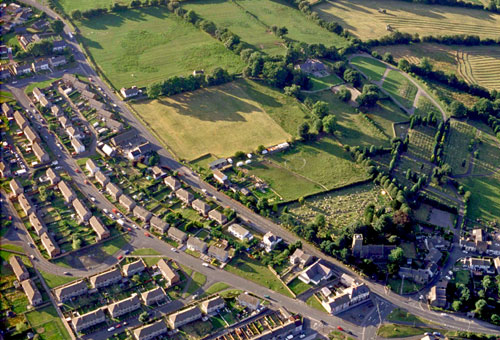
The historic landscape character area of Gelligaer Settlement comprises the ancient core of the urban settlement that has recently expanded to the south and west. The character area is bounded to the west and south by the B4254 and extends to the east as far as the Nant Cylla and to the north as far as the Cross Inn on Heol Adam. The area includes the sites of Roman forts and associated remains, the medieval earthwork castle of Twyn Castell to the south and the prominent church of St Cattwg with its cemetery. The origins of the nucleated settlement of Gelligaer go back to at least the Roman period. The site was chosen for an important earth and timber fort, constructed as part of the 1st century campaigning and military dispositions in South Wales. Occupying a commanding position on the broad spur of Cefn Gelligaer about 240m above O.D. it was positioned strategically on the line of the Roman road running south from Brecon, via Penydarren and Caerphilly, to Cardiff. This permanent Flavian fort was investigated by the late Professor Michael Jarrett in 1963 who established that it was a large rectangular earthwork about 6 acres in extent. Previously this had been considered to be a marching or construction camp. However, this fort was replaced in c 103-111 A.D. by a smaller (3.7 acres) stone fort situated immediately to the south-east.
The earthwork remains of this establishment are clearly visible in the field to the north-west of the Church of St Cattwg. The significance of this fort lies in the fact that it was largely excavated (albeit haphazardly) in 1899-1901 by members of the Cardiff Naturalists' Society, who produced a textbook plan for the internal arrangements of an early 2nd century fort.
The later fort remains a significant feature in the historic landscape character area, which benefits also from other buried archaeological remains in the form of a 3rd-4th century (?) fort annexe to the south-east containing the remains of the regimental balneum (bath-house) - one of the finest known in Wales. In addition the remains of Roman kilns have been uncovered in the churchyard and the site of the roughly paved parade ground has been identified to the north-east of the fort. The line of the Roman road is preserved in the modern course of Heol Adam as it extends towards the open countryside of Gelligaer Common to the north, where it survives for considerable lengths as a prominent earthwork feature in the landscape.
Two key elements survive in the modern landscape as reminders of the medieval settlement that existed at Gelligaer. These are the remains of Twyn Castell, a strongly fortified earthwork castle 150m to the south-east of the Roman fort, and the impressive Church of St Cattwg.
The construction of the earthwork castle has been attributed to the Welsh rulers of the mountain commotes of Senghenydd. It may have been the fortress of Cadwallon, the son of Ifor Bach, mentioned in the Pipe Roll for 1197-98. Following the English annexation of Senghenydd in 1267, Gelligaer became one of the demesne manors of the lordship of Caerphilly and the castle may have ceased to function militarily at that time. The remains consist of a large steep-sided mound or motte with a flat top of roughly oval shape, set in a narrow ravine. No evidence for a defended bailey or settlement has yet come to light.
The castle probably dates to the 12th century as may the current parish church of Gelligaer situated on slightly higher ground to the north. The Church of St Cattwg, lying adjacent to the Roman fort, may be seen as evidence of continuity of settlement developing from a Roman/sub-Roman cemetery as attested elsewhere. The church first appears in documentary sources in 1254. The churchyard recorded on the Tithe Map of 1842 was curvilinear in shape. The church consists of nave, separate chancel, west tower with outshot stair turret and south porch and contains remains of most periods from at least the 13th century.
Historic Landscape Characteristics
The area is characterised by the nucleated and ancient settlement of Gelligaer, which has been an important military centre and community since the Roman period. The historic core, which is a conservation area, contains nationally important monuments that demonstrate a long and diverse continuity of occupation. The ancient core of Gelligaer, as distinct from the modern urban conurbation extending to the south and west, is a recognisable, distinct and important character area. It represents a historic settlement of considerable importance, time-depth, variety and rarity in the uplands of south-east Wales.