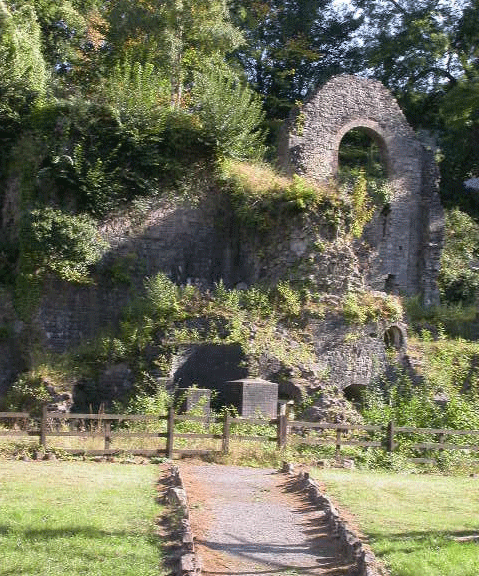
Clydach Gorge
003 Clydach South

HLCA 003 Clydach South
Nationally important industrial landscape dominated by 18th century ironworks (excavated) and associated settlement; nucleated-organic and ribbon settlement pattern with early ironworkers' dwellings; non-conformist Chapel; mid-20th century pre-fab dwellings; industrial rail; bridges; and industrial water supply.Back to Map
Historic Background
The historic landscape area of Clydach South comprises the late 18th century Clydach Ironworks and the core of the associated industrial settlement, which evolved in a haphazard manner from the late 18th century. The settlement has in effect been grafted onto the late-medieval/early post-medieval agricultural landscape of evolved/irregular and small regular fields and the layout largely respects the pre-existing winding lanes and field pattern in ribbon fashion, the main departure being Club Row.
Clydach Ironworks (SO 229132), excavated and partly restored during the 1980s, is currently the property of the Borough Council. The works was established here, close to the sources of iron ore, coal and limestone, by 1795 and exploited the recent introduction of coke as fuel. The blast furnaces at the site remained in production for over 65 years during which time the works were a focal point for much activity in the valley. By 1841 over 1,350 people (including 133 children under 13) were employed, the majority involved in winning iron ore and coal higher up the valley. In 1813 the site at Clydach boasted two furnaces, by 1833 this had increased to three with the blast supplied by a Boulton & Watt engine and a 42ft. wheel, while four furnaces were recorded for the first time in 1844.
In 1793 the first furnace at the site was under construction and production at the works started well with 1,660 tons in 1796, and after an initial drop rose steadily thereafter (2,658 tons in 1816: 6,771 tons in 1830; 10,038 tons in 1840). Edward Frere and Thomas Cooke with a nominal association with the Kendall family of ironmasters, who lent their name to the undertaking, operated the works, leased from the Duke of Beaufort. The business, however, was never really successful, the works being up for sale in 1813 and again in 1833. Between 1841 and 1845 the works continued to suffer financial losses, difficulties continued and by the 1850s the works was in decline, the furnaces ceased production in 1861, and despite the works being sold as a 'going concern' three years later and again in 1878, never returned to production.
Historic Landscape Characteristics
Clydach South comprises impressive remains of the 18th century Clydach lronworks (SAM: BR161(MON)), dominated by archway of a charging house, though little of the furnaces now survive apart from their bases. However enough survives to convey the importance of iron production to Cwm Clydach. The site of the nearby rolling mills (Dan-y-coed), and associated water supply features are perhaps less obvious. Beyond the remaining charging house was the coke yard where coal was burnt in heaps or ovens to produce the coke used in the furnaces.
An etching of 1811 shows the earliest two furnaces, with a large waterwheel to drive the blowing engines and indicates the original arrangement of a raised wooden 'launder', which formerly supplied water from a pond near the rolling mills.
In 1813 the rolling mills produced approximately 60 tons of rough bars and 80 tons of finished iron per week. By 1905 the property was in use as a Woollen factory.
Also of considerable interest is Smart's Bridge, dated 1824 (SAM: BR161(MON)), which is thought to have carried a tramroad linking the ironworks with the Clydach Railroad to the north.
The area also takes in a massive dump of slag from Clydach Ironworks 'the flat', which crosses the valley, the river culverted underneath.
The settlement itself is characterised by its predominantly ribbon pattern, which has developed to form an unplanned nucleation dominated by short terraces or rows (largely altered) of double fronted two storey ironworkers' cottages. The 'nucleation' appears to represent mid-19th century improvement/additions to a more loosely spread earlier settlement of smaller late 18th century/early 19th century cottages/rows. A large part of the current settlement comprises 20th century housing estates.
The cottages are usually built of pennant sandstone, although some Old Red Sandstone is in evidence; many of the buildings were apparently originally limewashed. Original features are rare, although a few retain small pained sash windows. Blind-backed rows are also in evidence, and are noteworthy. Some earlier examples (late 18th century) of dwellings were noted during the field visit, one in particular on Station Road retaining original small pained sashes and limewash finish.