Historic Landscape
Characterisation
The Rhondda
025 Mynachdy Penrhys
HLCA 025 Mynachdy Penrhys
Upland landscape; core area of medieval grange and pilgrimage site; historic,
cultural and religious significance; relict post-medieval field system
and farmstead(s); minimal industrial influence on the landscape; early
communications; documentary evidence; modern social housing, forestry
and leisure use.
Click here for character
area map
(Back to map)
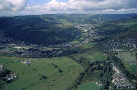
(Photo: GGAT HLCA025)
Aerial view of the character area with the Rhondda Fawr in the background.
The historic landscape area of Mynachdy Penrhys is an upland landscape of relict archaeology displaying the usual upland characteristics such as funerary monuments typical of the Bronze Age (2300-800BC); three such sites lie within the area, one of which located in an area known as Erw Beddau (acre of graves), was excavated in 1951. The name of the area, Penrhys ap Tewdwr, is said to derive according to tradition from the beheading of prince Rhys ap Tewdwr; the area is the supposed site of a battle between prince Rhys ap Tewdwr and Iestyn ap Gwrgant in c. 1085-88; the Bronze Age cemetery of Erw Beddau, mentioned above, has become associated in tradition with the battle. An upland ridge way route, of unknown date, running south from the better-known Y Gefn-ffordd is depicted on the cartographic record of the area.
During the medieval period the area became established as a pilgrimage centre and monastic grange. The tradition exists for the establishment of a Franciscan foundation of Robert the Consul, on the site, though the remains now visible belong to the monastic grange associated with the Cistercian Abbey of Llantarnam. Penrhys became famous for its well, Ffynnon Fair, which is still extant, chapel, shrine and hostelry, and a tradition exists that Edward II took refuge here in 1326, prior to his eventual capture. From the early 14th century the Cistercians gave up sheep farming and leased the lands at Mynachdy Penrhys, dividing the manor into over 30 holdings; it is considered that the result was a spate of boundary construction. At the time of the dissolution in the 16th century the statue of the Virgin was removed following the Royal decree of 1538, and the shrine dismantled. It is said that the timbers were taken to construct the nearby farm of Ty'n-tyle (Davies 1975; Pride 1969; and Williams 1990).
The first edition 6-inch OS map shows the core area of the grange, the farms of Pen-Rhys-ap-Tewdwr and Pen-Rhys-isaf dominated by fairly regular-shaped medium sized fields. By the third edition (1921, revised 1914-15) the only major addition to the area was the Penrhys Isolation hospital.
The pilgrimage site continues to be used, extensively by the Catholic Community; in 1953 a monumental statue of the Virgin was erected near the site of the chapel. The farmstead of Penrhys-uchaf, formerly a gable-end entry house (RCAHMW), was demolished and its site taken by an estate of nearly one thousand houses, built 1966-9 by Alex Robertson, Peter Francis & Partners. Short two and three-storey terraces with cement rendered concrete walls and monopitch roofs (Newman 1995). The housing estate is anachronistic to the Rhondda; exposed to the elements and linked to social problems, the development is now considered ill placed.