Historic Landscape
Characterisation
The Rhondda
008 Llwynypia
HLCA 008 Llwynypia
Rare example of early 1st phase pithead settlement in the Rhondda; planned,
compact nucleated colliery-built settlement of linear terraces, with mostly
2nd phase ribbon and hillside accretions; residential colliery settlement
with limited functional/morphological variety; early examples of colliery-built
terraced housing - 'Scotch Terraces' distinctive double-fronted terraced
cottages; Llwynypia Colliery Engine House, rare example of surviving industrial
monument in the Rhondda.
Click here for character
area map
(Back to map)
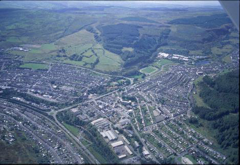
(Photo: GGAT HLCA008)
Aerial view of Llwynypia showing the 'Scotch' Terraces, foreground right
The historic landscape area of Llwynypia comprises the industrial settlement built on the land of Llwynypia and Glyncornel farms (Tithe of 1844), which belonged to the estate of the De Winton family. The Taff Vale Railway of 1856 passed south of the settlement, which by 1875 boasted beyond its colliery, an Inn, chapels, schools, a sawmill and a brickworks. The core or nucleus of the settlement, depicted on the 1st edition OS plan (1884, surveyed 1875), comprised a tight configuration of linear terraces, including Cambria, Llywelyn, De Winton, Glamorgan and Holyrood Terraces, known collectively as the Scotch Terraces, after the Scottish colliery entrepreneur responsible for their construction, Archibald Hood, owner of the nearby Glamorgan (Scotch) or Llwynypia Colliery. The terraces, built from 1865 onwards, are rare examples of housing dating to the period before the Public Health Act of 1875, which was later to have wide ranging effects on the construction industry. They are also of a less common type for the Rhondda being double-fronted, two-down three-up with facades overlooking long front gardens. Bricks used in their construction were made locally at the Llwynypia Colliery, using fireclay from its No. 3 Pit; the brickworks became the largest producer of bricks in the Rhondda area.
During the initial settlement period there is still a considerable break in settlement continuity between Llwynypia and the adjacent settlement of Ystrad and Gelli to the north, the continuous settlement landscape seen today emerges only with the publication of the 2nd edition. Minor additions to the settlement occur towards the turn of 19th/20th century with the addition of schools and two streets Railway View and Sherwood Street (2nd edition 6-inch OS map 1901, revised 1898), the latter in part a high quality speculative development of two storied, bay windowed houses aimed at owner occupiers (Fisk 1996). By the outbreak of World War I further expansion of the settlement had occurred with the addition of Hillside and School Terraces and Pont Rhondda Road. Improved facilities such as enlarged schools and the cricket ground north of Capel Salem are in place by this date (1921 edition 6-inch OS map, revised 1914).
Shafts 1, 2, and 3, of the Llwynypia or Glamorgan Colliery, also known locally as the Scotch Colliery, were sunk in 1862. Three additional shafts were sunk for pumping and upcast purposes under the Glamorgan Coal Company. The concern later became part of the Cambrian Combine in 1908 under DA Thomas, Liberal MP for Merthyr (1888-1910) and later Viscount Rhondda. Though coal extraction ceased in 1945, the mine remained open until the 1960s, after which the site was cleared. The Power House, or engine house, now a listed building, is the only reminder of the colliery on the site.