Historic Landscape
Characterisation
Merthyr Tydfil
055 Cefn Coed-y-Cymmer
HLCA 55 Cefn Coed-y-Cymmer Early industrial squatter" settlement: irregular dispersed layout with central linear ribbon core, wider streets near Pont-y-Cefn (associated with Crawshay family), early industrial housing; commercial function; religious, funerary and ritual: churches and chapels, transport corridor, road, rail, and electric tram and associated bridges
Summary
An important surviving industrial worker's squatter settlement, characterised by unplanned layout, early housing with a strong vernacular influence and non-conformist chapels of both rural and urban type. A major transport corridor characteristic is represented by elements such as the turnpike road from Cefn to Cwm Taff, the Brecon-Merthyr road, Cefn-Coed-y-Cymmer railway viaduct.
Historical background
The historic landscape area of Cefn coed-y-Cymmer has retained its distinct identity despite the spread of 20th century building around it. Compared to many of the settlements in Merthyr Tydfil, Cefn Coed-y-Cymmer has survived with much of its 19th century character intact; this is primarily due to it being until recently outside the borough. Early 19th century documentary evidence indicates that Cefn Coed-y-Cymmer originated as a squatter settlement. Theopholus Jones noted in 1809: "The village, raised in consequence of the neighbouring iron works at Merthyr is built upon the waste and houses are seen starting up without the slightest attention to regularity or arrangement, the convenience of each other or the preservation of health" (cited in Bowen 1992, 15). Thus it reflects a stage where the ironmasters had yet to assume control of all aspects of their workforce's lives. The irregular street pattern reflects this unplanned growth, although many of the buildings are of mid-late 19th century date. The expansion of population led to the construction of a chapel-of-ease in 1833, replacing a ruined medieval chapel (Bowen 1992, 243).
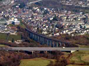
The area contains the remains of the BM and LNWR Joint Line, which is carried over the Taff Fechan by the impressive Cefn Coed-y-Cymmer Viaduct by Savin and Ward 1866 (listed grade II).
By 1894, Clarke noted that Cefn Coed-y-Cymmer was "situated two miles from Merthyr, and contains about 2,500 inhabitants" (1894, 35). By this time, the settlement had extended to the north along Upper High Street (north of the A465). There was a public tramway along the High Street in the early 20th century.
Intermixed with the housing the settlement retained transport links to the ironworks, mines and quarries, the most notable survival of which is the railway viaduct.
