Historic Landscape
Characterisation
Merthyr Tydfil
005 Penydarren
HLCA 005 Penydarren Industrial settlement: Iron Company
owned settlement of early dense scatter/cluster and, linear ribbon development
supplemented by planned settlement of regular linear blocks of terracing,
including early local authority housing
Click here for a character area map
Summary
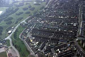
Penydarren originated during the early 19th century as an industrial settlement associated with the Penydarren Iron Company and its core consisted of a small cluster of cottages extended by ribbon development, later forming a more or less regular grid. Buildings are mainly regular linear terraces and the public buildings which served them, including a church, chapels, public houses and schools.
Historical background
The historic landscape area of Penydarren evolved during the early 19th century on land acquired by the Penydarren Iron Company (part of land belonging to Gellifaelog Farm). The initial settlement comprised a small cluster of cottages adjacent to lane to Gwaelod-y-Garth (Tramroad Lane) at junction with the road to Dowlais and a small number of cottages to the south of High Street. The period 1814 to 1840 showed further linear ribbon development south of High Street between the latter and the tramroad leading to Dowlais. The Tithe Map (c. 1850) depicted initial rows along the High Street and Penydarren Road and indicated the street layout under construction in the area beyond, including Church Street and Plantation Street, though the area to the north was still farmland.
By 1879, the settlement of Penydarren included rows to either side of High Street extending as far southeast as Nantmorlais. The original ear]y core adjacent to Tramroad Lane extended as far as Plantation Street, Church Street, North Sweet, Upper North Street and Penydarren Road, upslope and parallel to High Street. Also evident by this date were Elim Welsh Baptist Chapel and burial ground to south of North Street, St John's Church and school, Church Sweet. At this date a tramline from the Morlais limestone quarries, to the north was still a feature of Tramroad Lane. The filter beds to north of Penydarren (Penybryn Water Works) indicated sanitation improvements of the period.
The addition of Brynhyfryd Street - four blocks of linear terracing by 1897-98 marked a change in the layout of the settlement; this street and almost all the later streets was set at a right angle to the earlier street alignment. Later terracing, complete by 1919, including Urban, Council (the latter two sweets, dating to 1903, contain the earliest examples of council housing in Merthyr) Brynheulog, Lloyds Terrace and Williams Place and Tanybryn place, Seward Sweet eventually formed the characteristic linear grid pattern, seen today. An exception was Gwaunfarren Road, the northern boundary of the settlement, which includes terraces and semi-detached housing (some with bay windows); this was set on a similar alignment to High Street.
By 1905, the settlement boasted at least two inns, a public house and Post, while Tramroad Lane no longer retained its tramlines. Over the following 14 years the area gained schools to the north at Cwm Rhyd-y-Bedd including the Infant School, while another school had been built to the west of Tramroad Lane removing the earlier core settlement. Development had also begun on the adjacent 'garden city area' to the north, near Gellifaelog Farm (see HLCA 050).
